Etchings Institutions search term: west point
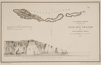
Anacapa Island | ||
| Number: | 2 | |
| Date: | 1854 | |
| Medium: | etching | |
| Size: | 134 x 227 mm | |
| Signed: | no | |
| Inscribed: | no | |
| Set/Publication: | U.S. Coast Survey, 1854 | |
| No. of States: | 1 | |
| Known impressions: | 16 | |
| Catalogues: | K.App.1; M.app. 1 | |
| Impressions taken from this plate (16) | ||
STATE
One state is known.
State 1

With lettering at the top, above the ruled frame: 'PLATE No. 414'; within the frame, at centre top: 'ANACAPA ISLAND'; at the right: 'U. S. COAST SURVEY / A. D. BACHE, Supdt./ Sketch of ANACAPA ISLAND / IN / SANTA BARBARA CHANNEL / By Lieut. T. H. STEVENS, U. S. N. Assist. U. S. C. S. / 1854'; at the left: "Note. Anacapa Island is due East of Santa Cruz Island in (approx.) Lat. 34 [degrees] 00' and Long. 119 [degrees] 23' W. from Greenwich Observatory. Variation of the Magnetic Needle, 13 [degrees] 21' E."; at the bottom centre, 'View of the Eastern extremity of Anacapa Island - from the Southward.'; at the centre, a vertical arrow indicates 'Magnetic Meridian'; at the bottom, under the ruled frame, on the left, 'Drng by W. B. McMurtie' and on the right, 'Engg by J. A. Whistler, J. Young & C. A. Knight.'
