Anacapa Island | 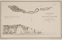 Hunterian Art Gallery (46661) | |
| Number: | 2 | |
| Date: | 1854 | |
| Medium: | etching | |
| Size: | 134 x 227 mm | |
| Signed: | no | |
| Inscribed: | no | |
| Set/Publication: | U.S. Coast Survey, 1854 | |
| No. of States: | 1 | |
| Known impressions: | 16 | |
| Catalogues: | K.App.1; M.app. 1 | |
| Impressions taken from this plate (16) | ||
KEYWORD
coastline, landscape, map, sea, seascape.
TITLE
The title was published by the U.S. Coast and Geodetic Survey, although it was literally etched by Whistler and his colleagues at the Survey:
'ANACAPA ISLAND' (Whistler et al., 1854). 1
'Anacapa Island' (U.S. Coast Survey, 1854). 2
The plate itself bears several inscriptions, including the title at the top, 'ANACAPA ISLAND', and at the right, 'U.S. COAST SURVEY' and 'Sketch of ANACAPA ISLAND / IN / SANTA BARBARA CHANNEL'
'ANACAPA ISLAND' (Whistler et al., 1854). 1
'Anacapa Island' (U.S. Coast Survey, 1854). 2
The plate itself bears several inscriptions, including the title at the top, 'ANACAPA ISLAND', and at the right, 'U.S. COAST SURVEY' and 'Sketch of ANACAPA ISLAND / IN / SANTA BARBARA CHANNEL'
1: Etched on the copper plate.
2: As published by the U.S. Coast and Geodetic Survey, 1854.
DESCRIPTION
At the top of the plate is a schematic plan of the chain of three islands and offshore rocky outcrops of Anacapa Island. Below this is a profile view of the high cliffs at the eastern end of the island, ending to right in a natural arch and point of rock. There are flights of birds above, and reflections in the sea below.
The etched inscriptions are recorded under 'COPPER PLATE'.
SITE

These islands are in the Pacific Ocean, off the coast of California. They are volcanic in origin, with steep cliffs. In 1542 Juan Rodriguez Cabrillo sailed by the islands and called them 'Las Islas de San Lucas'. In 1770 another Spanish explorer, Gaspar De Portola, named them 'Velo Falsa' (false sail); and in 1774 Juan Perez renamed them 'Isletas de Santa Tomas'. In 1793 Captain George Vancouver called them 'Eneeapah', spelled 'Enecapa' on his maps. This derives from the Chumash Indian word, 'Eneeapha' or 'Ennepah' meaning the island of deception or mirage. Finally the U.S. Coast Survey in 1852 named it 'ANACAPA' on their charts. In 1848 with the Treaty of Guadalupe Hidalgo, Anacapa Island became a part of California territory, and thus, in 1850, part of the new state of California. 3
3: www.lighthousefriends.com; www.theresourcemag.com / LightHouse.asp; www.west.net/ ~scifmail / anahist.html; www.nps.gov / chis / historyculture / anacapaisland.htm (accessed 2008).
The islands were a hazard to ships, and, at 11 p.m. on 2 December 1853, the side-wheel steamer Winfield Scott ran full speed into Middle Anacapa Island in dense fog. The ship was a total loss though the passengers abandoned ship safely in a disorganised manner. This prompted President Franklin Pierce to issue an executive order reserving Anacapa for lighthouse purposes.
The U.S. Coast Survey visited Anacapa in 1854 and concluded: 'it is inconceivable for a lighthouse to be constructed on this mass of volcanic rock - perpendicular on every face, with an ascent inaccessible by any natural means.' Eventually, a lighthouse was constructed there in 1932, administered by the Lighthouse Bureau until 1938, when President Franklin D. Roosevelt assigned National Monument status to Anacapa Island. 4
4: Ibid.